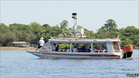
Google begins Amazon river Street View project
- Published

Google is expanding its Street View service into some of the world's most remote places.
It will photograph the Amazon and Rio Negro Rivers of northwest Brazil in partnership with charity Foundation for a Sustainable Amazon (FAS).
Google will train local people to collect images, and will leave behind equipment so work continues long-term.
Pictures will be stitched together so users can explore 360-degree panoramics of the area.
FAS approached Google two years ago with the plan to digitize high-quality images from the Amazon basin to demonstrate the effects of poor global sustainability efforts and widespread deforestation on the landscape.
FAS project leader Gabriel Ribenboim said: "It is very important to show the world not only the environment and the way of life of the traditional population, but to sensitize the world to the challenges of climate change, deforestation and combating poverty."
For Google, the project represents the biggest challenge for their Street View equipment, which was first designed to work over well-maintained, modern roads.
Google's engineers will use the Street View "trike", originally developed to reach off road areas - such as Stonehenge and Kew Gardens.
"We'll pedal the Street View trike along the narrow dirt paths of the Amazon villages and manoeuvre it up close to where civilization meets the rainforest," Google described in a blog post.
"We'll also mount it onto a boat to take photographs as the boat floats down the river."
In addition to the street-level pictures, it will use technology developed to photograph business premises in the US to take images within buildings and community centres along the river.
Google hopes doing so will give a "sense of what it's like to live and work in places such as an Amazonian community centre and school".
The project will start in the town of Tumbira, where the California-based company has attracted much attention.
Resident Maria do Socorro da Silva Mendonca had never heard of Google, but is excited by the project.
"I don't know anything about the Internet," the 40-year-old mother told AP.
"I think it is wonderful because our community was never published anywhere, not even [big Brazilian city] Manaus.
"Nobody knows we are here."
Google's Street View service was launched in 2007, at first just covering a few US cities.
In 2009, major UK cities and towns were added, prompting privacy fears.
Last year Google was forced to apologise for "mistakenly collecting" data from open wireless networks as Street View vehicles captured images.
- Published16 August 2011
- Published17 August 2011
- Published14 August 2012